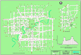
 The above map can be found at http://www.edmontonprt.com/Public%20Transit%20in%20Edmonton.htm
The map depicts the traffic flow patterns in Edmonton, Canada. the depiction shows traffic volume by correlating the with of the depicted road with actual traffic volume. The map also includes a bar graph indicating overall flow by time of day. The Double peak shows the typical "rush hour" traffic. While the map gives a picture of overall usage, it does not necessarily give an idea of congestion or actual use at any given time. Obviously there are more influences on traffic flow than daily usage. This map does not indicate road type (i.e. limited access hwy, open access 2 lane, etc), type of usage (car, commercial shipping, bus), type of travel (in-town, through-traffic), nor does it indicate directionality of traffic. All of these could influence the actual picture of traffic at a given place and time.
No comments:
Post a Comment