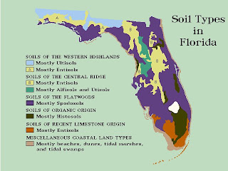
 The above image, taken from http://www.luddist.com/environm.GIF, shows a nominal area choropleth map. The area is divided by color, representing the soil type found in the corresponding area.
Subscribe to:
Post Comments (Atom)
 The above image, taken from http://www.luddist.com/environm.GIF, shows a nominal area choropleth map. The area is divided by color, representing the soil type found in the corresponding area.
No comments:
Post a Comment