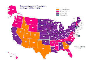
The above image, taken from http://www.census.gov/population/www/pop-profile/sttrend.html is an example of an unstandardized choropleth map. In this case the areas used are determined by the political boundaries of the individual states. While this may give use useful information to use for state-level decisions, it may not reflect the actual occurrences at city or county levels. While there may be a large shift one way for the state, it is possible that no shift, or even a shift in the opposite direction could be possible at the local level.
No comments:
Post a Comment